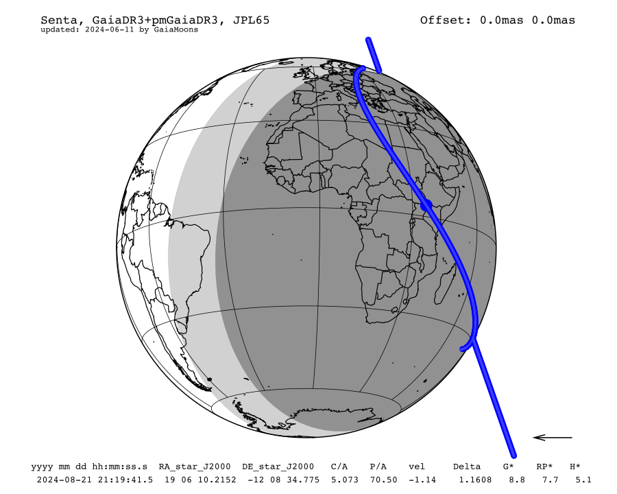
Occultation by (550) Senta, 2024-08-21
To return to the main page, click here
Occultation map

(*) The blue dots are separated by a one-minute interval and the big blue dot corresponds to the nominal occultation time (which is the geocentric closest approach).
Occultation circumstances
| Occultation event id | 21744 |
| Date at closest approach | Wed. 21 Aug. 2024 21:19:42 |
| Star position (ICRF) | 19 06 10.2152 -12 08 34.775 |
| C/A | 5.073 arcsec |
| P/A | 70.50 ° |
| velocity | -1.14 km/s |
| Geocentric distance Δ | 1.1608 au |
| Star G magnitude | 11.9 |
| Magnitude drop | 0.9 |
| Max occultation duration (main body) | 33.2 sec |
| Moon distance to the object | 72.6° |
| Fraction of illuminated Moon | 93.5 % |
| Solar elongation | 136.5° |
| Prediction source | JPL65 |
Star & Object data
Occulted star informations
| Star source ID | 4198663413310843008 |
| Stellar catalogue | GaiaDR3 |
| Star astrometric position in catalogue (ICRF) | 19 06 10.2166 -12 08 34.766 |
| Star astrometric position with proper motion (ICRF) | 19 06 10.2152 -12 08 34.775 |
| Star apparent position (date) | 19 07 33.6767 -12 06 17.720 |
| Proper motion | μRA* = (-2.5 ± 0.0)mas/yr; μDEC = (-1.0 ± 0.0) mas/yr |
| Source of proper motion | GaiaDR3 |
| Uncertainty in the star position | RA* = 0.2 mas; DEC= 0.1 mas |
| G mag* | 8.8 |
| J mag* | 7.7 |
| H mag* | 5.1 |
| RP magnitude (source: GaiaDR3) | 10.8 |
| BP magnitude (source: GaiaDR3) | 13.2 |
| J magnitude (source: 2MASS) | 9.1 |
| H magnitude (source: 2MASS) | 8.2 |
| K magnitude (source: 2MASS) | 7.9 |
| RUWE (source: Gaia) | 0.91 |
Main Object informations (primary)
| (ID) Object | (550) Senta |
| Primary diameter | 37.9 km |
| Uncertainty in primary diameter | 1.09 km |
| Apparent primary diameter | 45.0 mas |
| Semi-major Axis | 2.59 au |
| Object astrometric position (ICRF) | 19 06 10.5416 -12 08 33.093 |
| Object apparent position (date) | 19 07 34.0027 -12 06 16.026 |
| Apparent magnitude | 12.2 |
| Source | Gaiamoons |
| Binarity nature | Suspected binary |
| Priority index | 2 |
Binary system estimated informations (satellite)
| Estimated separation 1 | 55.81 km |
| Uncertainty in separation 1 | 6.24 km |
| Estimated separation 2 | 50.77 km |
| Uncertainty in separation 2 | 5.86 km |
| Diameter (sol° 1) | 5.86 km |
| Uncertainty in diameter (sol° 1) | 0.17 km |
| Max occultation duration (sol° 1) | 5.14 s |
| Diameter (sol° 2) | 34.75 km |
| Uncertainty in diameter (sol° 2) | 7.87 km |
| Max occultation duration (sol° 2) | 30.44 s |
| Wobble Period | 10.51 h |
| Uncertainty in wobble period | 0.03 h |
| SNR | >1 |
Sky map (Aladin)
link to sky-map
For declination above -25 °, Pan-STARRS survey is displayed by default whereas below -25 °, DSS is displayed.
For declination above -25 °, Pan-STARRS survey is displayed by default whereas below -25 °, DSS is displayed.
Interactive Map
Observation advice
To be able to observe the asteroid satellite, we recommend, if the satellite is in the path of the primary body, that you start recording your observations preferentially around 1min beforehand.
Interactive map legend
By clicking on one place, you will have an infobox with :
To be able to observe the asteroid satellite, we recommend, if the satellite is in the path of the primary body, that you start recording your observations preferentially around 1min beforehand.
Interactive map legend
- Large blue lines : Primary body's limits of the nominal prediction.
- Large dotted blue line : Centrality of the nominal prediction, which is the center of mass of the system.
- Large red lines : Area where the satellite can be at the time of occultation, which is the largest acceptable estimated separation limit.
- White area : Represents the daylight part on Earth and the blue area represents the region on Earth where the object is not visible.
- Shadow at nominal time is displayed, the brighter part represents the uncertainty in the body's radius.
- Sun symbol indicates the place where the Sun is at the zenith at the nominal time.
- Star symbol indicates the place where the occulted star is at the zenith at the nominal time.
- Grey zone : Night area withour occultation.
By clicking on one place, you will have an infobox with :
- Coordinates: Longitude and latitude;
- ρ and Δd: Impact parameter (i.e. projected distance to the central line) and σ distance; Δd is (ρ-r)/σd where r is the object radius and σd is the uncertainty in distance;
- Mid time: Mid time of the occultation at the selected place
- Expected duration (main body): Expected duration of the occultation of the main body at the selected place
- Max expected duration (satellite): Expected maximum duration of the occultation of the satellite at the selected place, the two values corresponds to the two possibles solutions for the satellite diameter
- Object elevation: Object's elevation above the horizon at the selected place at the mid time
- Airmass: Amount of Earth's atmosphere that starlight passes through to reach a telescope
- Sun and Moon elevation: Sun's and Moon's elevation above the horizon at the selected place at the mid time